
Monday, 8 August 2011
Astore, Pakistan. The entrance of the valley is located about 60 km southeast of Gilgit with four side-valleys. The majority of people practice subsistence agriculture and livestock is the main source of livelihood complemented by seasonal work in down districts of the country. Due to its diverse landscape and climatic conditions the valley provides excellent habitat for a variety of commercially important medicinal plants.


"Arror Rock" [near Rohri in Sindh] The shape of rock was caused by unknown natural forces. There is also a Shrine on the top. In France, there is a famous similar shaped rock on sea shore caused by huge water waves but in the middle of barren Arror - such a shape is an Amazing Wonder. Near this wonder, there are ruins of Bin Qasim Masjid [First ever Masjid built in Subcontinent; during reign of Muhammad Bin Qasim]


Ansoo Jheel, Pakistan. The name “Ansoo” comes from its tear-like shape [the Urdu word Ansoo means teardrop]. This lake also resembles Human Eye with central ice land resembling Iris of Human Eye and a ridge resembling Eyebrow becoming even more prominent when ice melts on the Eyebrow in summers. Ansoo Lake is a high-altitude lake [elevation 16,492 feet or 5,027 metres] in the Kaghan Valley in the Mansehra District of the Khyber-Pakhtunkhwa province of Pakistan. There is no risk free way to reach lake waters because it lies in the crater with steep, snow covered walls. There is no apparent drainage of lake water and no one ever tried to explore it because of its dangerous approach and limited resources in that area!

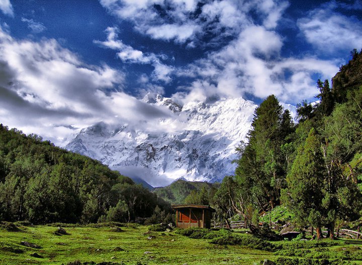
Nanga Parbat, Pakistan. Nanga Parbat is often referred to as the highest mountain face in the world: the Rupal Face rises 4,600 m [15,000 ft] above its base. To the north, the complex, somewhat more gently sloped Rakhiot Flank rises 7,000 m [23,000 ft] from the Indus River valley to the summit in just 27 km [16.8 miles], one of the 10 greatest elevation gains in so short a distance on Earth. Nanga Parbat has never been climbed in winter!
The Baltoro and other glaciers of the Karakoram, Pakistan are the largest and longest in the world outside the polar region. From it's spectacular birthplace in Concordia, at the base of K-2 and the gasherbrum range, the Baltoro Glacier flows for more than 59 kilometers, a rippling, pitted, pockmarked river of ice, where great glaciers slide and slither together before separating to go their different ways. (Kindly Join the group: Pakistan That We Never Knew! and post the comments over there)

Subscribe to:
Posts (Atom)